Data collectors are small electronic devices, like rugged calculators, that help surveyors record measurements automatically, instead of writing and drawing by hand on Field Notes. They connect to tools such as total stations and GNSS receivers, cutting down manual work, reducing mistakes, and making it easy to move data from the field to office software.
Data collectors are about the size of a pocket calculator and run simple operating systems like Windows CE. They use software such as Carlson SurvCE, Trimble Access, or Topcon Magnet to talk to surveying instruments.
- Enter point IDs, station names, and descriptive codes
- Add settings like date, time, and weather
- Log angles, distances, and coordinates automatically
When linked to a total station or GNSS receiver, data collectors can control the instrument, receive data, and perform basic calculations. But how does this happen?
The field software inside the data collector sends digital commands through cables or wireless links (like Bluetooth or Wi-Fi). These commands tell the instrument when to take a reading, where to aim, or what settings to use. Once the instrument measures angles or distances, the data is sent back instantly to the collector. The data collector stores this, applies real-time corrections (like scale factors or refraction), and may even convert it into coordinates right away.
Some data collectors can also function as electronic field books. In this mode, they are not connected to surveying instruments like total stations or GNSS units. Instead, surveyors manually enter their readings and notes directly using the keypad. This is useful when working with older tools that cannot connect digitally. Although less efficient than automated mode, it still allows digital recording of field data for later processing.
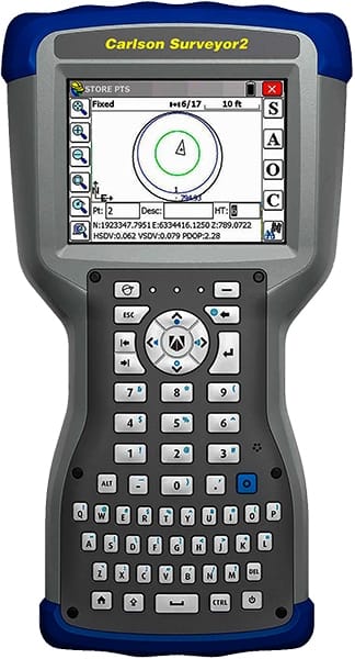
Many modern data collectors, such as the Carlson Surveyor2, offer both modes. They can be used independently as field books or connected wirelessly (via Bluetooth or Wi‑Fi) to surveying equipment for real-time, automated data capture. This flexibility makes them suitable for both legacy and advanced surveying workflows.
Survey data is saved as either binary (fast but not easy to read) or ASCII (text files you can open on any computer). Common file types include raw data (unchanged measurements) and coordinate files (editable results).
- USB or RS-232 cable
- Bluetooth or Wi‑Fi
- PCMCIA memory cards
- Wireless modems for remote areas
Field-to-finish means using codes in the field so CAD or GIS software can draw features like lines and symbols automatically. This cuts down on manual drafting and speeds up map creation.
Always back up survey data quickly. Use removable disks, CDs, DVDs, cloud storage, or extra hard drives. Keep at least two copies to avoid losing data if a device fails.
- Fewer manual entry errors
- Faster data processing and map making
- Immediate field checks (like closure tests)
- Great for large surveys
- Data loss if device malfunctions or gets deleted
- Cannot sketch freehand like paper
- Needs trained operators
- Not for long-term storage
Choose a data collector that works with your instruments and supports your file formats and software. Check connectivity options (USB, Bluetooth, Wi‑Fi) and make sure the maker offers updates and support.
The entire journey starts when a surveyor sets up instruments in the field and uses a data collector to record measurements. The device stores this data in organized files. After collection, the data is transferred to a computer or directly uploaded to office servers. There, the data is processed using CAD, GIS, or other mapping software. Thanks to the coded information and real-time corrections, the office team can generate maps or reports quickly — often without redrawing anything manually.
Data collectors like the Carlson Surveyor2 are key tools in modern surveying. They automate measurements, improve accuracy, and link directly to mapping software. Proper data transfer, backups, and training ensure smooth, accurate field-to-finish workflows.